Best Handheld GPS Units of 2024 Reviewed
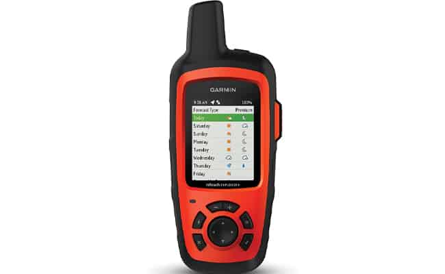
Garmin InReach Explorer+ Handheld GPS
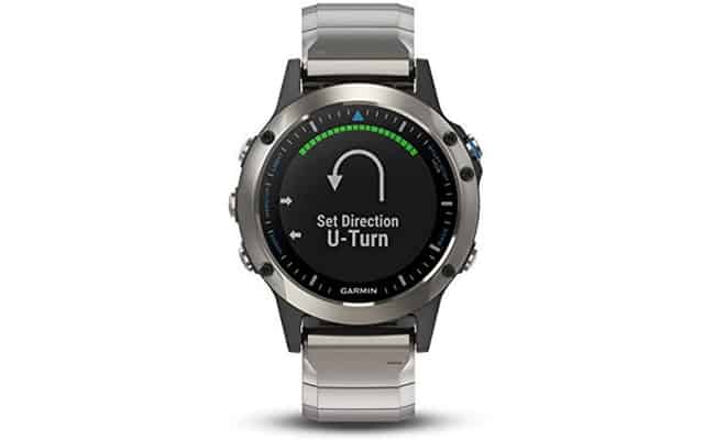
Garmin Quatix 5 Marine Smart Watch
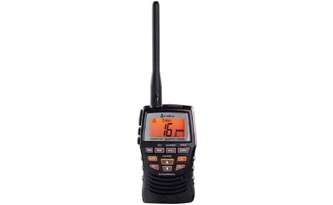
Cobra HH600 Handheld GPS and VHF Radio
Published by Ian Fortey in Boats Last updated on February 10, 2024
Looking for the best handheld GPS for your boat instead of a larger boat gps? Most handheld GPS units come from Garmin. They offer everything from barometric altimeter sensors to a wide area augmentation system. Whether you want touchscreen GPS, free spatial data, rechargeable battery packs, or VHF radio. If you’re not sure which is best, we have some suggestions to meet your needs.
Garmin InReach Explorer+ Handheld GPS
As you’ll see in our reviews, Garmin makes a lot of handheld GPS units. The Garmin InReach Explorer+ is next level, though. This is Garmin providing some top of the line power and technology right in your hand. If you want the best handheld GPS, this is it.
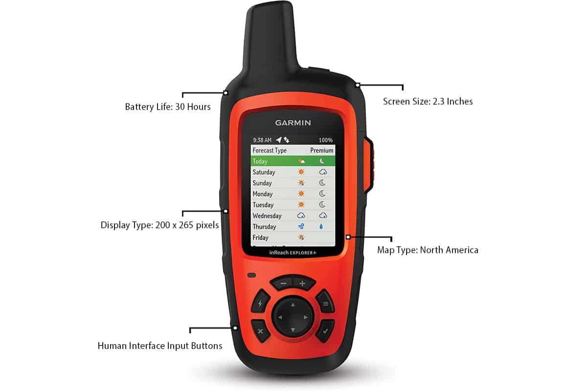
The InReach Explorer+ comes with preloaded DeLorme TOPO maps and on-screen GPS routing. Routes and waypoints are easy to create and save.
The biggest strength of the InReach Explorer+ is the reliability of service. Put this head to head against a satellite phone and see which one comes out on top. That’s even in the most remote locations. Keep in mind, you need to subscribe to their satellite service plans for this to work. That can range anywhere from $12 per month to over $50 per month depending on the level of service you want.
In terms of satellite reception, you want a clear view of the sky, obviously. Connecting to the satellite is relatively fast. If you’re waiting more than 5 minutes, be surprised. Typically, it connects much faster. You’ll know within about 20 minutes if your message went through or if it failed. Failures can happen, but this is rarely a service issue.
In case of emergencies there is an SOS button on the side of the unit. That goes directly to a 24/7 monitoring station for emergency services. If the worst happens, this is the best unit to have handy.
You can pair this with other devices and download the Earthmate app for free. That lets you download NOAA charts, additional maps and gps satellites images to use for navigation. GPS and GLONASS are standard. There are a number of GPS apps to use.
Like any good handheld GPS, it features an electronic compass and barometric altimeter. There’s also an accelerometer, something most gps units don’t have. It’s an interesting feature that senses movement to keep the unit up to date and tracking. The rechargeable lithium ion battery life is long lasting.
The big downside of this unit? Because it’s been on the market for about 4 years, technology has updated. Which is to say the tech here is still awesome, but the design is four years old. It’s a bigger unit in terms of how handheld is made these days. That’s not to say it’s like carrying around an iPad or anything. But it’s still bigger than some other units that are almost as good. The Garmin InReach mini is a great example. The thing that keeps Garmin on top is the reliability and accuracy of their tech. We think these are the best overall handheld GPS models on the market.
Garmin Quatix 5 Marine Smart Watch
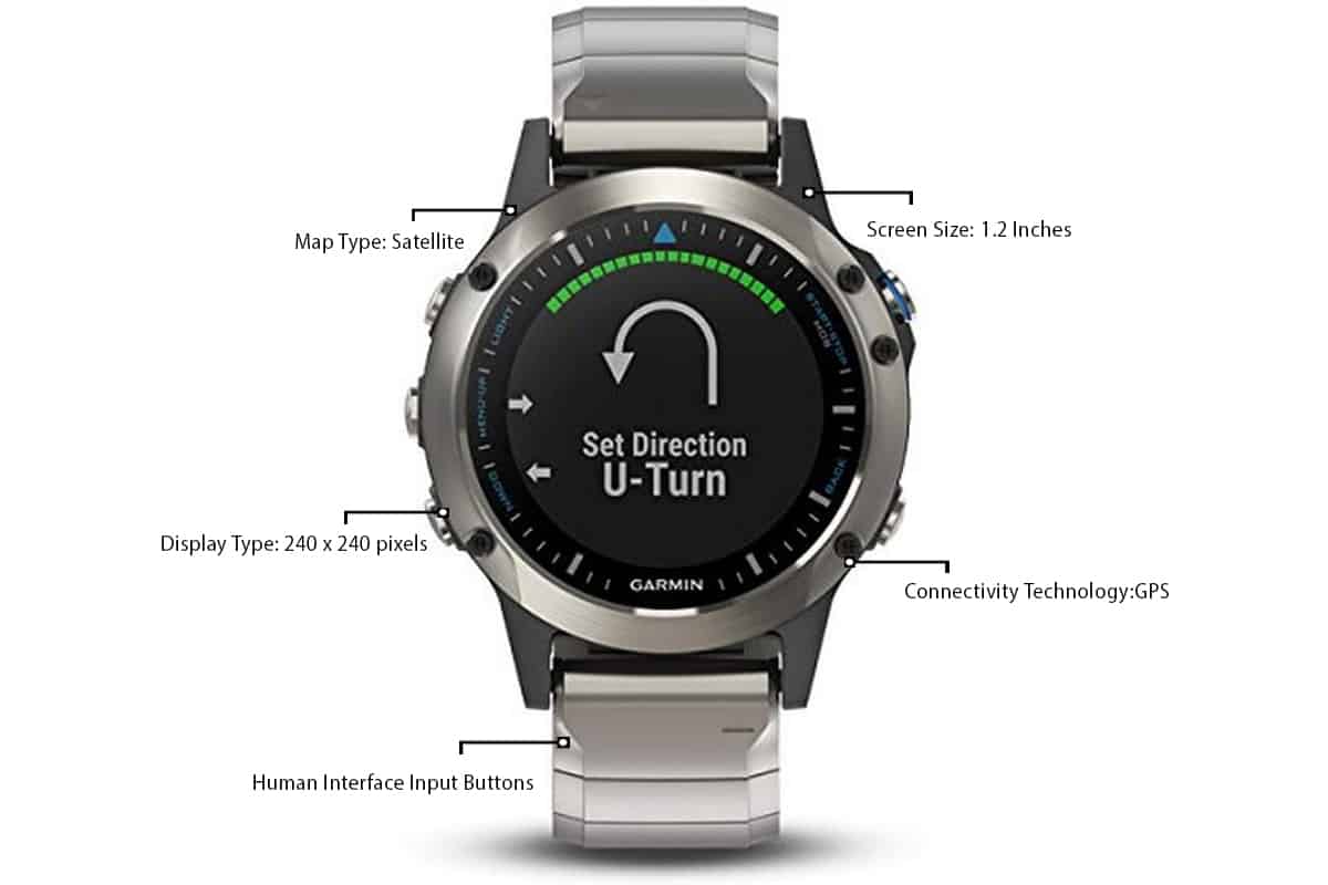
For the absolute best in portable tech, this is what Garmin has to offer. Why hold your GPS in your hand at all? The Quatix Marine smartwatch sits on your wrist and gets the job done. Best of all, it looks cool.
Like any GPS, this is fully connected and can plot courses and select waypoints for you. It easily connects to a wireless gps network. The features for something that seems so small are impressive. The watch features a GPS and GLONASS antenna. It also comes with pre-loaded marine features and charts. That means streaming NMEA 2000 data. There is also a barometric altimeter and tide tables. Plus, you can connect to a GHC 20 autopilot system.
Be aware that Garmin has released the Quatix 6 since the 5 came out. We’re sticking with the 5 as our recommendation, however. The 6 really seems to be a buggy device right now. Five has form and function, but 6 seems to be stuck on form. The software is just not up to par and, for the price, it’s a bit of a downer. But 5 has proven to be reliable for a while now. Until they update 6 and get it on track, no need to change models.
Among the other cool features as a sail racing assistant. It includes virtual starting lines, tack assist, and timers. There’s waypoint marking and data streaming. It covers everything from depth to temperature to wind. Heck, it even monitors your heart rate. Whatever you could imagine needing a marine watch to do, this has you covered.
Going out in a kayak or canoe? It even tracks performance metrics so you can see how you’re paddling.
The battery life is exceptional for a GPS but not that great for a watch. Keep that in mind if you pick one up. Your normal watch can probably last for ages without a battery change. This one, in GPS mode, is good for about 24 hours of battery life. As a smartwatch, they say it’ll last up to 2 weeks. So don’t be wearing it around the house all week before you go boating.
You can swatch the bands out easily and the face is scratch resistant. It’s also water resistant to 100 meters. Like other Garmin products, the connectivity to their network is superb. You can get texts and emails right on the watch when you’re out on the water. It can provide live tracking data and even post updates on your social media if you want.
Our advice is to get a screen protector. As tough as they say it is right now, give it some back up. Especially if you’re canoeing or kayaking. One wrong hit against a rock and you can chip the glass. Better safe than sorry and opt for additional protection.
The other thing you need to do is keep it clean. Especially if you boat in saltwater. If you let this sit, it’s going to corrode. The metal is designed for marine use, but it is not going to stand up to salt water for long. Use freshwater to clean it down and then dry it to make sure it has a long life.
Cobra HH600 Handheld GPS and VHF Radio
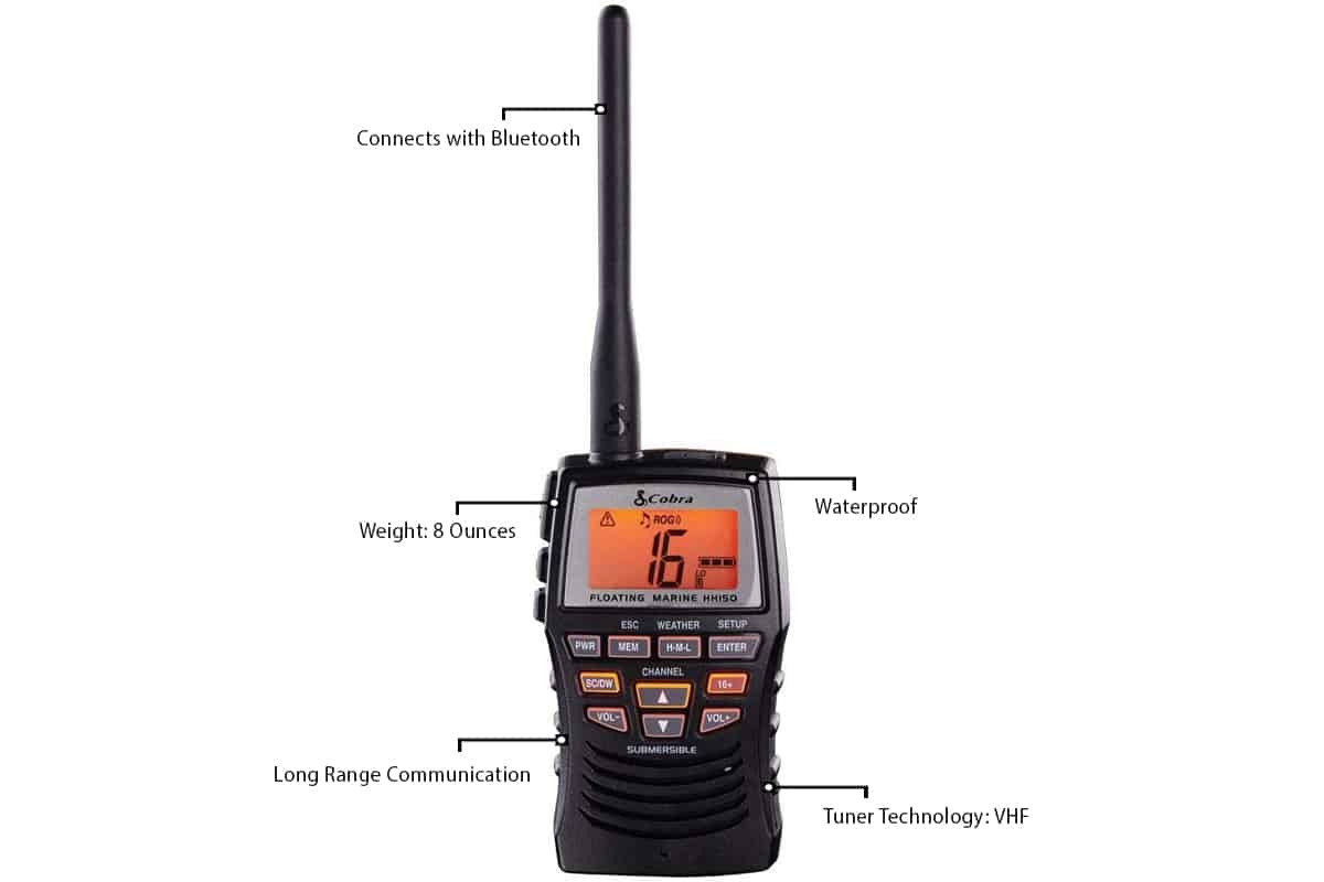
Yes, there are other makers of handheld GPS besides Garmin. But there aren’t many. And of the few others on the market, not all of them offer quality products. Cobra has a good track record for making quality communications devices, however. This offers both GPS and VHF.
This is not a chart plotter like some of these other GPS devices. You won’t be accessing preloaded maps or other interactive navigation data. That said, it does offer reliable communication and global positioning system tracking. It’s a solid VHF marine radio, and it’s built to last. The frame is sturdy and will handle some abuse on the water. Essentially, this is going to sub in for your actual cell phone. That way you don’t need to worry about it getting damaged or sunk to the bottom of the sea.
The Cobra connects with Bluetooth. GPS transmits your location. While many of the Garmin devices are geared for navigation, this one is a safety feature. The radio works even in wet conditions. There’s a man overboard button and instant access to emergency channels. It’s also fully submersible with the highest waterproof rating you’ll find.
We’re including this one on the list just because we know not everyone wants or needs navigation aids. If you want GPS just for the safety, and a reliable marine radio, this is fantastic. You can stay in communication with the shore in nearly any conditions.
Your only big concerns with this device are volume and hours of battery life. It’s not going to last all day. In fact, battery life can fade in as little as six hours. The sound quality can also be problematic. Depending on gps signal quality, transmission can be very quiet. That’s fine when you test it at home, but on the water it could be bad. If a storm is brewing, you may have issues hearing people.
Garmin GPSMAP 64X Handheld GPS
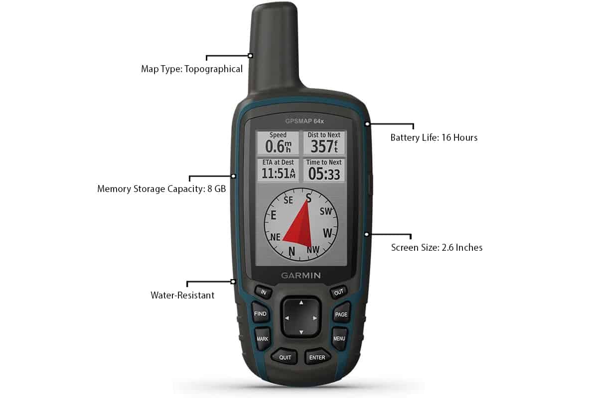
Built like a walkie talkie, this unit from Garmin takes portability to heart. It’s easy to hold and doesn’t feel clunky or heavy. Like any Garmin handheld GPS, it’s built to last. The unit is rugged and can take some abuse. If this slips and falls on deck, you don’t need to worry about it smashing to pieces.
The unit features multiple satellite systems support. That means GPS and GLONASS and Galileo. In practical terms, that means you’re getting the most accurate GPS data in the world. Battery life is listed at 16 hours in GPS mode, but we’re calling it a little shorter than that. However, if you hook it up to a solar charger, you can pad that time out considerably without losing function. When setting up the GPS, you can select battery type. Make sure you pick the right batteries! It does change how the unit functions and if you pick wrong, it can cost you. It can drop to 6 or 7 hours of battery life. That shorter battery life can go by quickly.
In terms of usability, it comes loaded with topo maps. The screen is small, but this is a handheld unit so that’s obvious. It’s 2.6” but at least it’s a sunlight readable display. You definitely want to avoid cheaper units that suffer glare issues. There’s nothing worse than having to lean over and shield your GPS screen to try and read it.
Like other Garmin units, this has a built in 3-axis compass. A digital compass like this is a great feature. It also comes with a barometric altimeter to gauge your altitude. It also measures barometric pressure to track the weather. There’s also 8GB of internal memory on board. You have the option to use memory cards to pad that out as well when internal memory won’t cut it.
You can pair the unit with other devices to send texts and emails on the go. If you’re chatting with family or meeting friends, this can be really helpful.
ICOM Marine Handheld GPS and VHF Radio
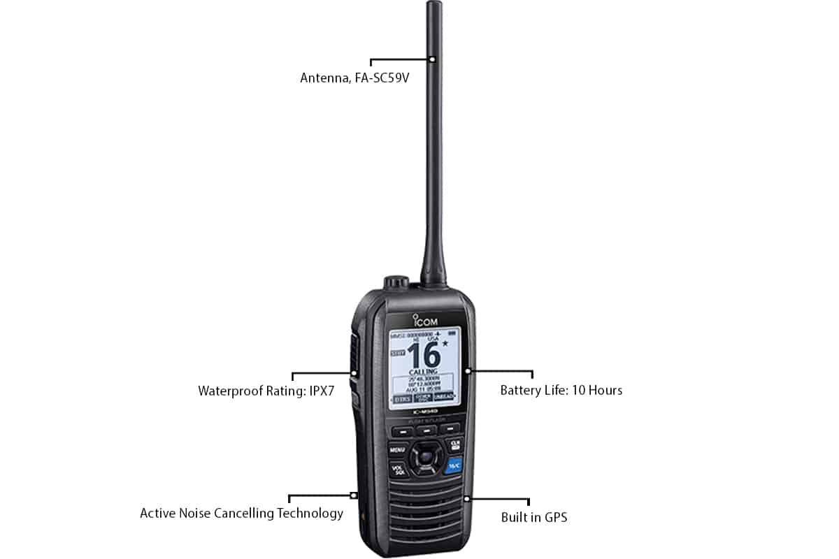
Like the Cobra, the ICOM is a combination of both GPS and VHF radio. Mixing the two together allows you to communicate with shore while you navigate. The noise cancelling handset makes it easier to hear people, even in rough conditions. There’s also a feature that helps push water away from the speakers. This helps to ensure clear communication. It’s a handy little tool. To be sure, it doesn’t have the fancier capabilities of some of the Garmin devices. But that doesn’t mean it’s not useful. And, at the price, it’s definitely worth a look.
Integrated GPS allows you to keep up with location, speed and bearing. The large screen can be seen easily in sunlight. That way you can set navigation information without having to hide in a shadow.
The Float n’ Flash safety feature sets off a strobe light if the device hits the water. The memory will store 50 waypoints for you. With access to GPS and GLONASS, QZSS and SBAS (WAAS/EGNOS/MSAS) it offers great accuracy.
The company offers a reliable 3-year warranty. The only drawbacks are in the operation. As part of the slim design, the buttons are very small. In a pinch, or with wet fingers, they can be hard to manage.
Garmin GPSMAP 78S GPS and Chartplotter
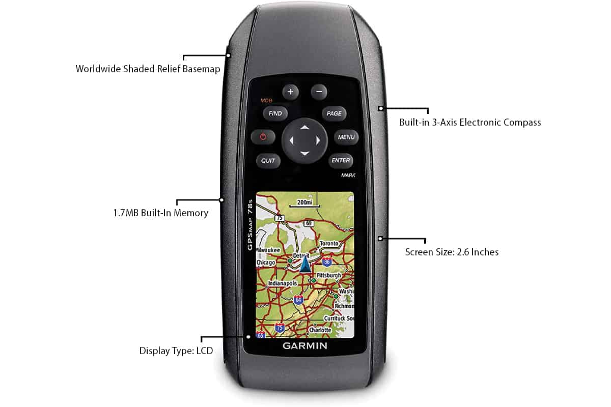
Here comes Garmin GPS yet again. The fact is Garmin dominates the high quality handheld GPS market. The Garmin GPSMAP 78S is incredibly easy to use, and it can chart on and off the water. The accuracy is what you’d expect from Garmin and it’s incredibly fast. It has a WAAS enabled GPS receiver. It also uses HotFix satellite prediction. That means top of the line speed and reliability.
Even though you can use this unit for driving or hiking, it was clearly made with marine use in mind. It has a man overboard function and, of course, it floats. There’s a built in barometric altimeter included to help you find your altitude. This can also keep track of potential changes in the weather.
The basemap covers pretty much every place you can get a boat on Earth. No need to worry about uncharted waters here. It also has a 3-axis compass. Cheaper units require you to hold the GPS unit level. Not so with this one. No matter where it’s sitting the compass will adjust. That way it can tell you where the current is taking you even if you’re at a standstill.
Information is easily shared electronically from the unit. Geocaches, waypoints and routes can all be sent anywhere you like. That makes it easy for friends and family to know where you are, or to meet up with you.
You have the option of adding downloadable maps to this unit if you want. You can download them and transfer with a microSD card. The card, sadly, is not included. The additional maps cost extra cash, though. By that we mean several hundred dollars, depending on the map. A lot of them seem to be roadmaps for us when you’re off the water. There are also marine charts available. Just so you know ahead of time, this unit does not have marine charts preloaded. If you were expecting them, you’ll be disappointed.
It also supports BirdsEye Satellite Imagery, but that requires a subscription as well. It’s a very cool feature that lets you integrate satellite photos with your maps. That said, it’s not necessary for it to function so you can skip it with no worries. The download speeds for these images are kind of slow, anyway.
With a good memory card you can store thousands of waypoints. Also tons of satellite imagery. The rechargeable batteries are pretty powerful and you can keep them running for over a day. Hook up a solar recharger and you’ll be enjoying a long run.
Things to Remember About Handheld GPS Devices
Picking the best handheld GPS devices is not as easy as buying the first handheld GPS device you see. There are a few factors you want to consider. The best handheld GPS units will hit many of these marks.
Portability
As we have seen, portable isn’t a hard and fast term. Some of these units are bigger than others. Even Garmin doesn’t make every handheld unit the same size. How you need to use your handheld GPS really comes into play here. Are you on a fishing boat or in a kayak? Will you have it mounted on the boat, in your hand, or just sitting on a flat surface?
Boaters who spend a ton of time at sea tend to opt for larger handheld GPS units. Portable units are definitely more casual. They work best in smaller boats or for people who boat once in a while. They offer the diversity of going with you in the car or on a hike.
The Screen
Right now you can pick up a no-name marine handheld GPS on Amazon for probably less than $50. And it’s almost guaranteed that one of two things will happen. The screen resolution will be so terrible it will be nearly impossible to make out any features. Or the moment you try to use it under the sun, the glare will make the screen invisible. It’s likely both will happen.
You absolutely must get a screen that can be viewed in the sun. This really isn’t an option. If the screen suffers glare there’s no point. And finding shade on the open water is never easy.
A large screen size and good resolution are also a big help. Obviously you’re not getting a massive widescreen TV here. But a small unit can still have a decent screen. And with good resolution you should make out all the important features. A handheld GPS is only as good as the screen. If you can’t see what it’s showing you, all the fancy bells and whistles mean nothing.
Power Supply
Few things get critiqued more than power supply when it comes to handheld GPS. The battery life of handheld GPS devices has to be exceptional, or what’s the point? If you’re out on a boat you’re going to be there for a while. You need batteries that can last the duration.
Garmin boasts devices that can stay powered for over 100 hours, which is great. Many devices operate on two AA batteries, however. You need one that can make the most of a regular power supply like that.
We recommend using rechargeable batteries. The best way to use these with handheld GPS devices is to pair them up with a solar recharger. Solar chargers are not too expensive and they’re not too big either. Pair it with some typical rechargeable batteries. This can more than double your battery life on a trip.
Maps
A handheld GPS that doesn’t know where to go isn’t much of a GPS. You need to check and see what kind of maps come preloaded. Many of these units will have a world basemap, and that’s great. But what if you want detailed charts around Puget Sound? You can buy mapping software online and upload them to your GPS. But be aware that some of these can be incredibly expensive. Also, you’ll need a way to get them onto the handheld GPS device. That typically means a memory card, which costs extra as well.
Topographical maps and marine charts should be what you’re looking for first thing. Obviously you want them related to where you are and where you’re going. If you plan to boat around the world, you’ll likely need a lot of new maps. If you stay in the Gulf of Mexico, you may be able to find just a couple of charts to meet all your needs.
Chart plotting handheld GPS devices are typically much more expensive. That makes sense though when you factor in the level of detail they provide. Nautical charts are going to give you water depth, buoys, coastal features, and much more. This is a serious boating feature. It’s cool to have, but not always necessary.
Some handheld GPS units are non-mapping. We’ve included a couple of VHF radios with GPS in our reviews here. These can allow you to plot a course with way points. There are no maps included, however, and their display doesn’t support them. It really depends on how you want to do your boating. If you want charts to follow, the Garmin models are the way to go. But if you’re more interested in the GPS just tracking you, then maybe another model will work.
Navigation Aids
Higher priced handheld GPS units tend to offer more bang for your buck. They have the maps and the GPS link up, sure. But they can offer additional items.
- Electronic compass: It never hurts to have another compass around. The electronic compass in most portable GPS units is a great tool for assisting with navigation. It should be a 3 axis compass. That means you can use it standing, sitting, upside down, whatever. It can correct itself and track the movement of the boat easily.
- Barometric Altimeter. A barometric altimeter is a great tool for helping determine your altitude. It measures barometric pressure so it will be useful in charting weather patterns. If a storm is brewing, the changes in barometric pressure can give you a heads up.
- Birdseye Satellite Imagery: Having birdseye satellite imagery is a very cool feature. But it can cost a lot. It adds another layer of detail that you may find helpful.
Interface
This one is hard to manage when you buy online. You can’t try it out first to see how well it works. Some handheld GPS units are awesome but still have a tough user interface. There can be a learning curve to figure it out. Once you get the hang of it, maybe it’s great. But it can take a while to figure out sometimes, and that can be a hassle.
Ideally, you want a simple interface. One that is intuitive and user friendly. The more features a handheld GPS unit has, the less simple the interface tends to be. It’s just harder to manage all of those functions in a simple way. If you’re not a tech savvy person, keep this in mind. It can be easy to get frustrated with a GPS device, especially a handheld one. With smaller buttons and a smaller screen, you may find yourself annoyed, especially when wearing gloves.
Waterproofing
There are two main differences between terrestrial handheld GPS units and marine handheld GPS devices. The first is maps. Terrestrial GPS is going to focus on roadmaps and hiking trails. Sure, you can download new maps and apply marine charts if you want. But that brings us to the second difference. Marine GPS devices are intended for marine use. They are designed to be waterproof. They need that. Most GPS devices are water resistant, but not all. They can get splashed and maybe be exposed to rain. Drop them in the water, though, and they are done.
The best handheld GPS device can fall off the boat and keep working. It should be able to float as well. That’s something a terrestrial unit will not do. Obviously you don’t want to get it wet or have it fall overboard. But if those things happen, you want a device that will survive.
Maintenance
This is an important part of high quality handheld GPS operations. There are typically only two things you really need to maintain. First and foremost, check you batteries. GPS battery life is often short. Especially when compared to almost any other piece of similarly sized technology. This can catch people by surprise. If it looks like a cell phone, some users expect it to last as long as a cell phone. That’s not always the case. Always keep your batteries fresh or charged before use. Battery life will always vary with function and use.
The other thing is keeping it clean and dry. Sure, it should be waterproof. But when you’re done for the day, make sure you clean it off, especially if it was in salt water. Then make sure it dries well. Saltwater has a way of wearing out things really fast when they are left unattended.
Real-Time Tracking
This is pretty important for finding the best handheld GPS. Real-time tracking doesn’t suffer the lag of some cheaper GPS units. One that only updates every so often can miss a lot of key information. And, in an emergency, it can cost a lot of valuable time. Tracking in real time shows you where you are all the time, as soon as you want to know it. This is great for leisure activities like finding a fishing spot. But it’s crucial as a safety feature. If you end up adrift in a current, or the weather turns, your position is important to know.
Real-time tracking often comes hand in hand with Bluetooth enabled smart notifications. This feature is extremely helpful in an emergency. If another boat needs assistance, if a storm front is moving in, you need to know. Likewise, you can use this feature to tell others if you are in distress.
Reliability
There’s a reason Garmin popped up so many times on our review. Garmin is reliable. That’s why they’re considered the best handheld GPS out there. At the end of the day that is the most important factor in buying a handheld GPS. It can cost $10 or $1000. It can have a tiny screen or a huge screen. It can float, it can send texts, it can pilot your boat for you. But if it’s not reliable it’s worse than garbage. Sounds harsh, but an unreliable GPS could end up leading to a serious accident or worse. It’s just not worth it to skimp on reliability.
You need trusted and tested technology. A network that is proven to be there all the time, not just once in a while. You want a high-sensitivity receiver. One that is able to connect with multiple satellites. That means it will have increased speed and gps accuracy.
Some people have a negative preconception about “name brand” products. Why pay for the name when you can get the same thing for half the price elsewhere? That may be true of canned food or even sneakers. It’s just not true for GPS devices. These are attached to satellite networks and you need a proven brand with a proven record. The ones we have recommended today have all been tested and shown to be reliable. Even if you don’t like our recommendations, do your homework. Don’t sacrifice reliability for price, it’s never worth it.
Where’s the Garmin eTrex?
A lot of people recommend the Garmin eTrex 20 as a great marine GPS unit. And it was pretty good. It’s also discontinued. They still pop up on Amazon or reseller sites like eBay. But the odds on it being brand new are pretty slim. You can find terrestrial models of the Garmin eTrex also. Remember, this version of the Garmin eTrex is not designed for marine use. Things like the Garmin eTrex 10, the Garmin eTrex 20x are not marine specific. The Garmin eTrex 30x has also been discontinued.