How to use dividers
Published by Chris Riley in Tools and Calculators Last updated on November 25, 2022
Navigation Tools
Using dividers and the latitude scale on your nautical chart, you are able to measure distance in nautical miles. (Remember, do not use longitudes to measure distance. Longitude lines converge at the poles and the distance between them changes relative to your position on the earth.)
One minute equals one nautical mile. Examine the scale of your chart. In these examples, our chart is in degrees and minutes.
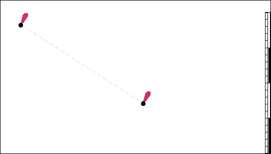
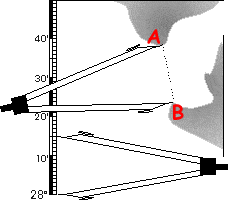 Place one point of the dividers at position A and the other point at at position B. Then, maintaining the spread, measure the distance using the latitude scale. In this case, the distance is 15 minutes or 15 nautical miles. Always use the latitude scale located in the same horizontal region that you are measuring.
Walking the dividers enables you to measure distances greater than the span of your dividers.
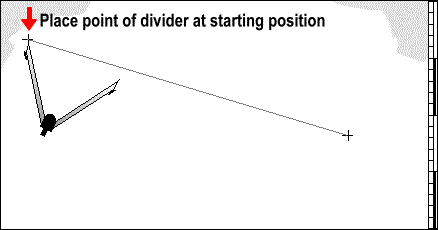
You can either draw the line or use a straight edge to guide the dividers.
To measure, set the dividers to a whole number, in this case we use 12, and walk the dividers along the line.
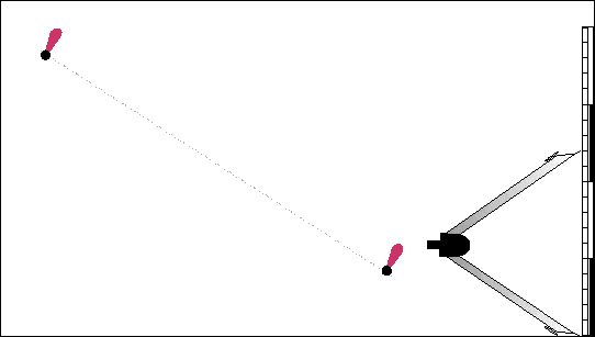
The distance between the buoys is 24 nautical miles (two steps of 12 miles each). But it doesn’t always work out so evenly.
Here we adjust the last step of the dividers, measure the distance, and add it to the cumulative total of previous steps. We only had one previous step in this example so the distance measured is 12 plus 7.75=19.75 miles. If we had stepped the dividers two times before adjusting for the final measurement, the distance measured would have been 12 plus 12 plus 7.75 or 31.75 miles.
Not All Dividers are Created Equal

No doubt you’ve noticed that navigation dividers look an awful lot like a compass used in drafting or math. There are various calipers and dividers used in numerous industries, in fact. Doctors use them, engineers use them, and more.
In practical terms, some of these dividers are easier to use than others. And at sea, many boaters have come up with some faster and easier solutions to using them.
Many traditional navigation dividers can be a little stiff or clunky. Not all, but some are designed that way. They’re best used with two hands on flat ground. Basically, you want to use them before you head out to see. But what about on the water? If you’re doing some commercial fishing, for instance, and need to mark dead reckoning positions. What now? A traditional set of dividers may be too clumsy to use in the moment. If you’re looking for instant numbers, you need a tool that works in one hand. Enter the drafting compass.
When you’re dealing with fix intervals as short as two minutes, speed is as important as accuracy. A drafting compass can do that. It’s lightweight but accurate and reliable. Look for one that’s at least 7 inches long. A well made compass will have a high quality set screw that allows you to secure the legs. That means looking for professional quality. A school quality compass will not work. Look for ones used by professional draftsmen or architects.
A good drafting compass will allow you to locate position by radar tangents extremely quickly. In just seconds, really. You can plot latitude and longitude with your GPS quicker as well. Arguably, plotting time can be cut in half.
Drafting compasses have a small pencil lead in one leg. That allows you to work faster than fumbling back and forth with dividers and a pencil. If speed is key to plotting course and other navigation points, give it a try and see what you think.
Categories: Tools and Calculators