Ranking The Best Boat GPS On The Market

Garmin Striker 4
Humminbird Helix 5 G2
Garmin Echomap Plus 94sv
Published by Joe Appleton in Boats Last updated on October 11, 2022
A Marine GPS is an indispensable piece of equipment for the modern boat owner. Working out where you are on the land is hard enough, but it’s a far more difficult task when you’re out on open water. Historically, sailors would have to rely on their years of navigational experience, understanding complex sea charts and determining their position and heading by using the positions of the sun and stars. Luckily, modern technology has evolved to make marine navigation far easier than ever before.
The modern devices rely on GPS (Global Positioning System) technology. GPS works with satellites to pinpoint a location on Earth with incredible accuracy. It’s excellent for plotting routes, determining directions, avoiding other naval traffic, and alerting emergency services in the event of an accident. Traveling the seas without one is a dangerous game.
But there are so many different kinds of boat GPS speedometer, tracker, fish finder, and chartplotter devices out there. They can be dashboard mounted systems, or portable handheld marine GPS products. But which one is the right one for you?
We’ve put a list together of the best marine GPS devices out there to make your shopping trip a little easier.
Garmin Striker 4
The Garmin Striker 4 is the ultimate fish finding device. It’s a small and compact GPS that features a 3.5 inch color display, which allows you to find fish, mark positions, and navigate when you’re out on open water.
Fishing enthusiasts will love this boat GPS because it relays in-depth information about what’s going under the waves. Using a CHIRP sonar transducer that uses a continuous sweep of frequencies to map the deep and search for fish, the Striker 4 offers detailed information about fishing targets and potential fishing grounds.
You can place a waypoint market on your favorite fishing grounds using the GPS systems to allow you to find your way back on your next trip with ease. The advanced, high-sensitivity GPS system shows your exact position, direction, and heading, in relation to map points and markers, making for simple and easy marine navigation.
The device also logs your sonar history, operates as a GPS boat speedometer, calculates distance, depth, journey times, and water temperatures.
The Garmin Strike 4 features an easy to use keyed interface with simple buttons, a tilt and swivel mount, and a number of other cool mounting features. It does require a 12-volt battery, or special aquatic battery systems though—so keep that in mind.
Pros
Simple keypad operation
Advanced underwater imagery
High-sensitivity GPS system
Compatible with other Garmin maps
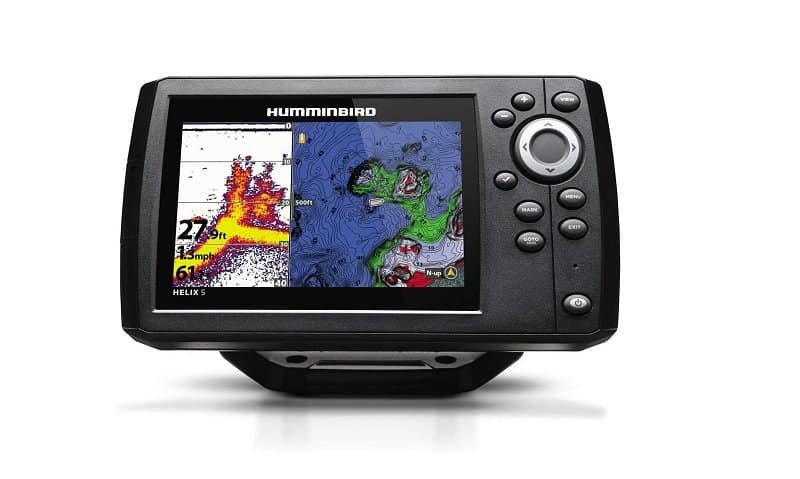
Humminbird Helix 5 G2
Humminbird is one of the most popular fish finding and mapping device makes in the United States. If you’re looking for a GPS-enabled marine system that can help you track down the best fishing spots and keep you on course at all times, then this could be the device for you. Ideal for both freshwater and saltwater pursuits, the Humminbird Helix 5 G2 has got your next voyage mapped out.
Suitable for pontoon fishing boats, SUPs, kayaks, right up to full-size ocean-going vessels, the Humminbird Helix 5 G2 has everything you need for a safe journey. Pre-loaded with maps and data from both LakeMaster and NOAA, the Helix 5 G2 is fully-capable of navigating you to your journey, noting buoys, hazards, markers, marinas, harbors, and other essential way points.
The actual GPS system uses WAAS technology to give astounding global positioning fixes, with an accuracy of within 2.5 meters. It also features a very accurate chart plotting tool, with using a built-in cartography tool from Anima.
If that wasn’t enough, the Helix 5 G2 is a competent fish finder. It uses CHIRP digital sonar and imagine sonar to map the lake or ocean floor, using live charts and down imaging to locate fish or potential fishing areas. All that data is produced onscreen in high-definition via the device’s 5-Inch color WVGA display.
Pros
MicroSD functionality for adding more maps
Mounting hardware and power cable are included
Simple keypad control interface
Amazing Side & Down imaging
Lowrance HOOK2 Fish Finder & GPS
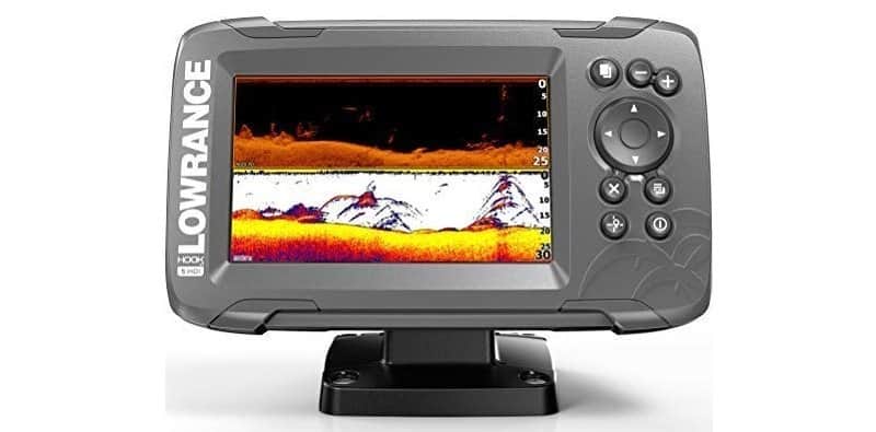
Lowrance is another name that you can trust when it comes to marine electronics. This particular model is a fish finder, chart plotter, and GPS all in one. It’s reasonably priced, has an easy to use interface, and it has a handy 5 inch screen too.
The fish finder relies on an auto-tuning sonar, that uses CHIRP sonar with an extra-wide cone angle that increases underwater visibility, giving you more coverage than other products on the market. It’s easy to control via the smartphone-like interface, allowing you to keep your mind focused more on fishing than fiddling with menus.
The HOOK2’s GPS capabilities are quite advanced too. Thanks to the internal antenna, the HOOK2 enjoys a very accurate level of precision. It will easily find your location, and point you in the direction of your favorite fishing grounds, local marinas, and other key landmarks or waypoints.
You get quite a lot of cool things included in this package too. It comes with a tough quick-release tilt and swivel mounting bracket, an SD card slot for loading additional content, and C-MAPS US Inland Lake Maps installed as standard. These maps feature contoured charts for 3,000 lakes, as well as regular charts for a further 9,000 lakes.
Unlike some other products on this list, Lowrance has given the HOOK2 a one-year warranty covering parts and labor, which is a testament to the brand’s confidence in their products. This is one of the best marine GPS systems for lake fishermen.
Pros
Fish finder, chart plotter, GPS, all-in-one unit
Pre-loaded with US inland lake maps
Split-Shot transducer for detailed underwater imagery
One year manufacturer’s warranty
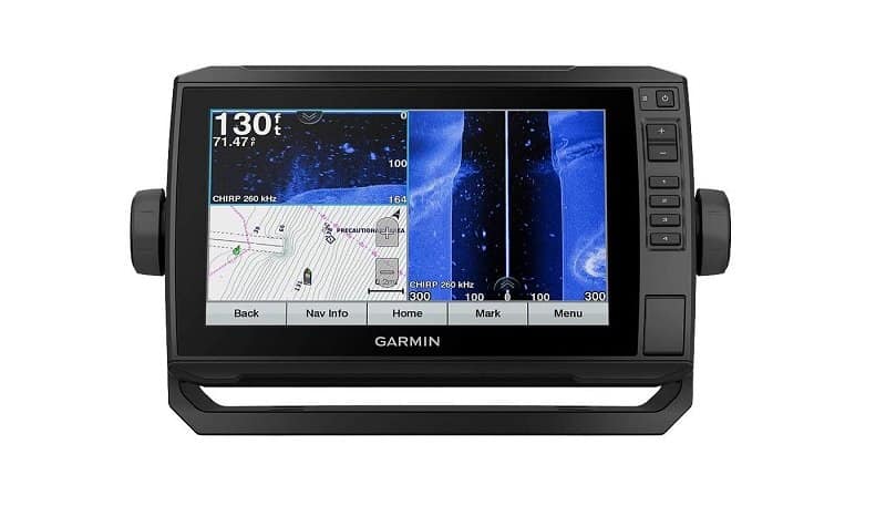
Garmin Echomap Plus 94sv
At the more premium end of the budget spectrum, we have the Garmin Echomap Plus 94sv. It’s an advanced GPS system with a useful 9-inch display and advanced fish finding technology. It’s pre-loaded with Bluechart G3 coastal charts, and Great Lake charts too, so it’s ideal for both saltwater and freshwater explorers.
The fish finder operates using a GT51-TM 12-pin transom mount transducer, that delivers CHIRP sonar, provides depth and temperature readings, and offers crystal clear imaging sent directly to the screen. With Quickdraw Contours, this Garmin boat GPS can create personalized fishing maps while you’re steering across the surface.
Thanks to built-in wi-fi technology, the Garmin Echomap Plus 94sv can seamlessly sync with your smartphone, allowing you to take calls, send text messages, and send emails directly from the GPS screen. It also allows for real-time updates to be added to your maps and charts, allowing you to plot courses accordingly, avoiding bad weather or other markers and waypoints.
What’s more, this Garmin GPS system is also compatible with a wide range of other Garmin products, and it can actually work in partnership with NMEA 2000 technology. This means that it’s possible to link your GPS to read engine data, external sensors, autopilot systems, and more.
Thanks to the simple screen and key-assisted interface, this Garmin GPS marine must-have is an essential piece of equipment for any coastal fisherman who enjoys exploring.
Pros
QuickDraw Contours live mapping
Wi-fi enabled interface for inter-connectivity
Bluechart G3 Coastal and Great Lake charts included
Fully compatible with other Garmin products
Cobra COB-MR
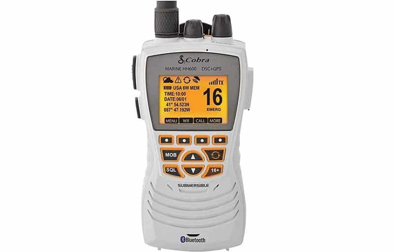
The Cobra COB-MR is a practical handheld marine GPS receiver with all of the necessary functions for boating enthusiasts, at an affordable price. If you regularly take your boat off-shore, then having something like this on board is an essential.
Cobra’s COB-MR device is a small and compact receiver that comes equipped with a VHF radio, access to NOAA weather channels with 24-hour weather updates, a built in GPS receiver, and a very useful Digital Selective Calling function, with a Distress Button.
While it’s not as advanced as many other products on the market, with fancy mapping or fish finding abilities, it can easily pinpoint your location, relay life saving information, and keep you on course.
It’s also Bluetooth enabled, waterproof, and designed to float. What’s more, it’s battery powered and will continue to function in emergencies, where hardwired equivalents would fail if there’s power loss.
To make the most of this marine GPS system, take the time to fully register your product and set it up using the manual.
For the price, it’s very hard to find fault with this cool GPS device. Sure, there are others out there but this one is ideal for budget-focused mariners, or as a backup for when other devices fail.
Pros
Instant access to Channel 9 & Channel 16 in emergencies
Submersible to IPX8 (JIS8) standards
Access to weather information at all times
3 selectable power settings
Ray Marine Dragonfly Pro 7
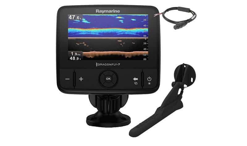
Next, we have this exceptional marine GPS and fish finding combo from Ray Marine. It’s not the most advanced GPS system in the world, but it can be used in partnership with a number of marine GPS apps, which makes it an invaluable tool for boaters.
The most impressive feature of the Dragonfly Pro is the fish finding sonar and Down Vision technology. It uses a dual channel CHIRP sonar to accurately map the sea floor to depths of up to 180 meters. The data received is model into quality maps that are then displayed on the Dragonfly Pro’s 7 inch LCD display.
The actual GPS side of this marine GPS unit features wi-fi enabled real-time up-to-date charts that keeps you on course and where you want to be. Bathymetric charts work with Ray Marine’s Navionics marine GPS apps to give you the latest navigation information. It can be used as a chartplotter, can record your journey, and drop waypoints and trail markers to help you find the same locations again and again.
If you’re looking for a device with a big screen and excellent clarity, with simple controls that’s easy to install, then this one is the model for you. It is quite expensive compared to some other models, but it does have a huge range of functions, making it quite a versatile bit of kit.
This particular model can be bought either with charts or without. Make sure you know which version you’re buying to avoid disappointment. “No chart” simply means that you’ll have to buy them separately and load them on manually.
Pros
Wide LCD screen
Built in wi-fi with smartphone compatibility
Live stream marine GPS chartplotter apps
Dual-channel CHIRP sonar
Standard Horizon HX870
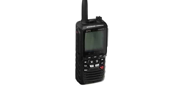
This is another handheld, highly-portable, and battery powered GPS system. This is from Standard Horizon, a big name in the radio-communications industry. It’s a VHF radio with an internal GPS system, with emergency call functions, with emergency alert and distress call capabilities.
The Standard Horizon HX870 uses WAAS technology to provide accurate location details, which users can transpose onto a paper chart. It also has a large dot matrix display that can be used for navigation, displaying your route, heading, speed, and location. Despite the old-school display, it actually has an easy route creation and waypoint marker system, which is invaluable at sea.
One of the best features of this device is the NOAA weather channel access that provides up to the minute weather alerts and reports around the clock. There’s also access to 70 Channel Class “D” DSC (Digital Selective Calling) channels, with a noise cancelling function for clear voice clarity no matter the weather conditions.
Other features include a USB data port for easy data transfer, a full-waterproof IPX8 waterproof rating, full flotation on water, and an easy to operate key interface. It also has a quick charging function that fully restores the lithium ion battery to full-life in around 3 hours. This is an excellent budget GPS device.
Pros
Water activated strobe light for emergencies
Fully waterproof, and it floats
Excellent battery life
Emergency distress call capabilities
Garmin GPSMAP 78SC
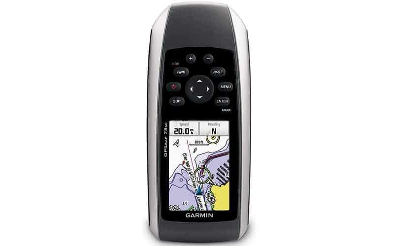
Next, we have a mid-range product from Garmin. This is the GPSMAP 78SC, a small marine GPS chartplotter device with loads of cool features that every watersports enthusiast needs to own. Not just watersport enthusiasts either—it’s a fun product that can be used for recording speed in your car, or recording flight date. However, it’s designed for aquatic purposes, and it’s best suited to those pursuits.
This boat GPS is equipped with BlueChart g2 coastal charts as standard, but you can easily load other maps using the microSD port. The coastal maps include shoreline details, depth contours, harbors, marinas, and navaids, for the entire United States and Bahamas.
Using a 3-axis tilt-compensated electronic compass, the GPS system can give you detailed information of your location, heading, and bearing. It also features a barometric altimeter that can detect your altitude, and plot barometric readings to predict changing weather and storms.
The WAAS-enabled GPS is a highly-sensitive system that can pinpoint your location easily. It uses HotFix satellite prediction tools that can log your location even in difficult conditions.
The device also uses Garmin Connect technology. This allows you to connect to your computer and trace or plan your routes using Google Earth, and share your routes and details with others.
Pros
2.6-inch color TFT display
MicroSD compatibility to add maps
20 hour battery duration
It’s water resistant and it floats too!
The Best Boat GPS: Buying Guide
What Is A Marine GPS?
A marine GPS is an essential marine navigation tool—but what does it actually do? As you can see from the list above, there are GPS emergency radios, fish finders, chart plotters, and more. Do all GPS devices do the same things, or do some serve different purposes?
First, let’s look at what a boat GPS actually does. It’s a global positioning system that can be used on bodies of water and over open ocean. They can pinpoint your exact location and give you your bearings. All GPS devices will at least do this.
Emergency GPS Systems
Some have emergency tools that allow you to call in help if you find yourself in distress. Others have live weather updates, live marine communication updates from other vessels, and other emergency functions. Many of these are handheld, battery-operated devices that can be used if your main power source is down.
GPS Fish Finders
Another popular kind of GPS system is a fish finder. These devices use transducer sonar to map the lake or sea bed, and track fish. The burst of scanning sonar bounces off of objects in the water, and the fish finder’s sensors convert the results into imagery that fisherman can read to determine the location of fish. These fish finders are very useful for fishing trips.
GPS Chartplotters
A GPS chartplotter or (chart plotter) is primarily a mapping and navigation tool. Like automotive satellite navigation products, these boat GPS trackers keep an eye on your location and plot your position on a map. They continuously monitor your exact position, your speed and heading, and plot your location in relation to land mass and other important markers or way points. They can also be used to store routes that can be loaded when you need them.
Important Features To Look For
Once you’ve got an idea of what type of GPS device you’re looking for, you can start focusing in on what other important features that you need. Here are some things to consider when you’re searching for a GPS system for your boat.
Maps
Maps are arguably one of the most important features of any GPS unit. However, not all marine GPS navigator devices come with maps installed. Some require your charts to be bought separately and uploaded to the device, while others have them pre-installed. There are some devices that don’t have any maps at all, simply relaying your co-ordinates which you can then note on a good old-fashioned sea chart instead.
Even if a device is pre-loaded with maps, make sure to check what areas they cover and what kind of water. Not all devices will have freshwater charts. Most will only have charts for your country.
Tools
Chart plotters and fish finders are great, but emergency tools are some of the most useful to have installed on your GPS marine navigation devices. Emergency calling and distress signaling is incredibly useful, particularly if you’re heading out to sea. Even if you’re staying close to the shore, accidents can happen, and having a device that can for help is a wise idea.
It’s easy to prioritize chart plotting as an essential feature, and it is an important feature, but safety should be just as important too. Some GPS systems have wi-fi that link up with marine GPS app programs that can be set up for emergencies.
Other cool features include an electric compass, a barometer, and weather updates. Keep an eye out for these when you’re shopping.
Portability
Do you need a battery-operated handheld device, or would you prefer a hard-wired, permanent interface? If you use multiple small-size vessels, it might be more economical to buy something portable that you can use on different boats from one day to the next. These devices usually don’t offer the same kind of features that more permanent-mounted devices do. However, if you primarily use one boat, it might be best to invest in a permanent GPS system. It all depends on your needs.
Power
If you opt for a handheld marine GPS navigator, then you should be mindful of the battery life. Some have standby times of over 20 hours, while others have quite limited 3-hour operational times. Naturally, what battery life you need depends on how long you’re on the water.
Some devices rely on your boat’s battery and motor to operate. These devices are more reliable but they do have some quirks to them. Always make sure that you read the voltage and motor type required to power one of these. Some trolling motors aren’t up to it, while bigger batteries can be overkill.
Even if you have a system that’s hooked up to your boat’s motor, it’s always wise to carry a battery-operated back-up, just in case of power failure.
Waterproof
A marine GPS unit should be waterproof. That should go without saying. However, there are different kinds of “waterproof” definitions. Here’s the official scale of waterproofing, and what level of protection each designation offers:
| Waterproof Designation | Water Protection Level |
| IPX0 | Absolutely no water resistance |
| IPX1 | Protects against vertical falling drops |
| IPX2 | Protects against vertical falling drops when tilted at 15 degrees |
| IPX3 | Protects against water spray at up to 60 degrees |
| IPX4 | Protects against splashes of water |
| IPX5 | Protects against water jets |
| IPX6 | Protects against powerful water jets |
| IPX7 | Fully waterproof up to 3 ft water depth |
| IPX8 | Fully waterproof in depths greater than 3 ft depth |
Interface
Another key feature to keep in mind is the user interface. Touchscreen devices usually feature nice wide screens with crystal clear displays. They can display a lot of useful information all at once. Unfortunately, touch screen technology can be tricky to operate in wet conditions.
Keypad controlled devices are simple to use and work well in wet conditions. Unfortunately, the actual control systems can be a pain to use, with laborious menus. More often than not, these keypad devices have smaller screens too.
The difference in price between the two types could help make that decision for you though.
Price
The price is arguably the most important factor to take into consideration when buying a marine GPS tool. Good quality equipment doesn’t have to be expensive, but you should be wary of a product’s limitations. If you go cheap, don’t expect it to have all of the top features that you’d hope for. It will be basic, but it should do the trick.
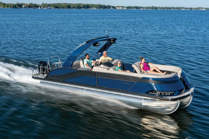
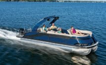
It’s also important that you don’t fall for the whole “it’s the most expensive so it should be the best” trick. Throwing money at a device isn’t the right way to go. It’s wise to make sure that you’re investing in a product that you actually want, will actually use, and suits your needs. There’s no point spending thousands on an ocean-ready GPS that’s designed for transatlantic journeys when you’re only fishing around your local lake in a pontoon boat.
Reviews
Lastly, always read the reviews. Don’t just take the word of marine GPS review sites. Make sure you check with other sources, writers, journalists, and forums before hitting the buy button. Also, if you’re buying from an e-commerce site like Amazon, then read the FAQs and reviews there too.
A certain product may ship without maps loaded into it, or with charts that don’t cover your area. The review section is the best place to mine for answers to those smaller, and often-overlooked questions.
The Best Boat GPS: In Summary
For sailors looking for a budget GPS option, or for those looking for an excellent backup system, then we recommend the Cobra COB-MR. It can easily calculate your position, runs off of battery power, and has an emergency alert system. It’s not the most advanced system, since it doesn’t boast any live charts, fancy imagery, or fish finding technology, but it is cheap, easy to operate, and very practical.
If you have a bigger budget, then the most impressive premium product on the market would have to be the Garmin Echomap Plus 94sv. A Gamin marine GPS won’t let you down. Ever! It’s an advanced fish finding tool with sonar technology, contouring imagery, and more. It also features a highly-sensitive GPS system, with detailed maps and amazing connectivity. Since it’s compatible with other Garmin products, it’s a very useful tool to have in your satellite-navigation arsenal.
For boaters who are just looking for a decent product that ticks all of the right boxes, won’t break the bank, and won’t fall apart easily, then we’d recommend the Humminbird Helix 5 G2. Primarily developed as a fish finder, the Helix 5 does everything a fish finder can, but it also has an advanced GPS system with an easy to use chart plotting tool. It scores big in terms of value for money, and that’s why we’ve named it as our favorite over all.


2 Comments
Spencer Meyers on July 11, 2020
Thanks for the excellent reviews! It can be hard to narrow down the product you are looking for. Too many times have I been in a hurry and purchased the first product that seemed to fit what I wanted. These Boat GPS systems seem to be more tailored to fishing. Are there different Security systems based on boat size or are they all in 1? Would a yacht require different boat security than a smaller fishing boat or does it come down to features? Thanks again!
Mark & Alpha Remaley on January 18, 2021
With so many choices I am confused. Our pontoon boat is in a relatively small (less than 1 aq. mi.) inland lake and I would like a really good depth profiler so I can see details on the bottom (for scuba-diving & curiosity), and a fish-finder. Those are the two things I really care about, and navigation in a small land-locked lake isn’t really a major concern, so in your opinion what unit would be the best for the limited conditions I have outlined? Thanks for any help on this.