The History of Navigation
Published by Chris Riley in Boats Last updated on February 19, 2024
Navigation is the art of getting from one place to another, safely and efficiently. Whenever you find a store in a mall or walk home from school, you are using the tools of the early navigators. But what if you found yourself in a place you didn’t recognize such as out in the middle of the ocean?
The earliest boats may date back hundreds of thousands of years, with some evidence suggesting prehistoric man may have used simple boats to navigate seas up to one million years ago. The oldest known boat that we can actually see and touch is called the Pesse Canoe. It was discovered during the excavation of a highway in the Netherlands. Carbon dating suggested it was built sometime between 8040 B.C. and 7510 B.C. indicating our ancestors had been at sea for a very long time.
The first record of boats large enough to carry goods for trade is around 3500 B.C. and this would mark the birth of the art of navigation. These first navigators stayed close to shore and navigated by sight of landmarks or land characteristics that they could see. Usually they traveled by day and sought a calm harbor or anchorage at night. They did not have charts but lists of directions, similar to today’s cruising guides.
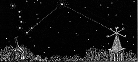 When they did venture out of sight of land, the navigator was able to determine his latitude (north/south direction) by observing the height of the sun during the day and the North Star at night .
Celestial Navigation
 Experienced mariners were said to plot their course by major constellations, though this was not an exact science. Vessels followed the east/west movement of the sun or the track of the stars. However, the navigator had no way to accurately determine longitude and therefore, once out of sight of land, had no idea how far east or west he was. Estimates were made based upon the time it took to get there, a simple form of dead-reckoning still used by navigators today. Phoenician sailors accomplished navigation in this manner around 2000 B.C. Simple charts and the use of sun and starts would have given them the early navigational edge.
Using this system, the navigator can determine the distance traveled from one point to another by multiplying the time underway by the speed of the vessel. Since time was measured with a sandglass and speed was estimated by watching pieces of seaweed pass by the hull, these early calculations were often way off.
Coastal navigators relied upon the sounding reed (c. Egypt 1500 BC) to measure shallow water depths and the wind rose which described the eight major winds attributed to their originating countries. Using a combination of depth soundings, the sun or stars and the wind rose, these early navigators had to guess where they were when land could not be seen.
The first ocean voyages were probably big mistakes – a vessel blown off course by a sudden storm or error by the helmsman. The Vikings regularly sailed to Iceland and Greenland between 900 and 1000AD, apparently using only the sun, stars and wind as their guide.
As brave as these early navigators must have been, they were also creative in compensating for their lack of technology. Floki Vilgjerdarsson, a great Viking explorer credited with the discovery of Iceland, carried aboard a cage of ravens. When he thought land should be near, he would release one of the birds. If it circled the boat without purpose, land was not near, but if it took off in a certain direction, the boat followed, knowing the bird was headed toward land.
Of course, this only worked if the navigator could get close to land. (And not too close!)
Using a Magnetic Compass
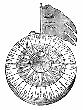 One of the earliest man-made navigation tools was the mariner’s compass, an early form of the magnetic compass (c.13 th Century) . Initially used only when the weather obscured the sun or the North Star, these first compasses were very crude. The navigator would rub an iron needle against a lodestone, stick it in a piece of straw and float it in a bowl of water. The needle would point in a northerly direction. Early mariners found the compass inconsistent – most likely because they did not understand that it pointed to the magnetic north pole, not true north (This is called variation ). At the time, they could not explain these variations and could not put much trust in the readings when navigating an unknown area.
The most practical use of the compass at this time was to identify the direction of the wind to help the navigator determine which of the eight winds on the wind rose they were experiencing. Even after the development of more modern compasses with pivoting needles, until variation was understood and documented, the compass was not as valuable to navigators as it is today.
![]() Much more valuable, at the time, was the invention of the lead line (c.13th Century) ., which was a tool for measuring the depth of water and the nature of the bottom. This line was weighted with lead and had graduated markings to determine sea depth. The lead was coated with wax to bring up samples of the bottom. A method of navigating from one depth to another based upon the condition of the bottom developed, with sailing directions from the 14 th Century reading “Ye shall go north until ye sound in 72 fathoms in fair grey sand. Then go north until ye come into soundings of ooze, and then go your course east-north-east.” (72 fathoms is 432 feet! That’s a long line.)
Much more valuable, at the time, was the invention of the lead line (c.13th Century) ., which was a tool for measuring the depth of water and the nature of the bottom. This line was weighted with lead and had graduated markings to determine sea depth. The lead was coated with wax to bring up samples of the bottom. A method of navigating from one depth to another based upon the condition of the bottom developed, with sailing directions from the 14 th Century reading “Ye shall go north until ye sound in 72 fathoms in fair grey sand. Then go north until ye come into soundings of ooze, and then go your course east-north-east.” (72 fathoms is 432 feet! That’s a long line.)
The development of better navigational tools was motivated first by commerce and trade, then by the riches of discovery. The Phoenicians and Greeks were the first of the Mediterranean navigators to sail from land to land and to sail at night. Often they navigated by bonfires set on mountaintops (the earliest known system of Aids to Navigation).
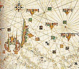 At this time, mariners began to realize that maps would be helpful and began keeping detailed records of their voyages that land-based mapmakers used to create the first nautical charts called Portolan Charts (c. 13th Century). The charts, created on sheepskin or goatskin, were rare and very expensive, often kept secret so that competing mariners would not have access to this knowledge. What they lacked in accuracy they made up for in beauty. Lands and ports on the chart were highly decorated with depictions of buildings and flags.
The size of the lands on the chart was more a reflection of their importance to trade routes than their actual geographical size. The charts did not have latitude or longitude lines but did have compass roses indicating bearings between major ports. They were, of course, not very accurate because the ability to measure distances at sea had not yet developed, nor was there an accurate method to portray the spherical surface of the earth on a flat piece of material.
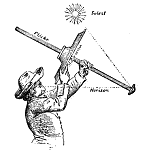 Mariners at this time also used the cross-staff and the astrolabe (c.1484 Martin Behaim) to measure the angle above the horizon of the sun and stars to determine latitude. The forerunner of the much more portable (and accurate) sextant , the astrolabe was used to measure the altitude of a sun or star. Heavy and clumsy, it was very difficult to use aboard a rolling ship, however, when new land was discovered and the astrolabe taken ashore, it was valuable in fixing the approximate latitude of the new discovery.
The hazards of sea travel during this time are clearly illustrated by Columbus’ experience. His journal reveals that he did not even know how to calculate latitude properly, his determinations being far too high. And like all sailors at the time, he was unable to calculate longitude. When he encountered the Americas he actually thought he had reached India which explains why the names Indies and Indians are still attached to the lands he found.
After a few weeks at sea the inaccuracies in the clocks could produce an error in longitude of thousands of nautical miles. It is likely that the best clocks at the time lost 10 minutes a day which translates into an error of 175 miles. This daily loss was not consistent, so it could not be compensated for.
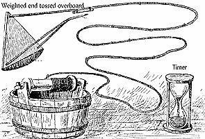 A major advance that made dead-reckoning much more accurate was the invention of the chip log (c.1500-1600) . Essentially a crude speedometer, a light line was knotted at regular intervals and weighted to drag in the water. It was tossed overboard over the stern as the pilot counted the knots that were let out during a specific period of time. From this he could determine the speed the vessel was moving. Interestingly, the chip log has long been replaced by equipment that is more advanced but we still refer to miles per hour on the water as knots. Using the sun and the stars, the navigator knew his beginning and ending latitude – now he could determine the distance he had traveled to estimate his east/west position.
 The first accurate representation of the spherical earth surface was the Mercator Projection (Gerardus Mercator 1569). Of great value to navigators because a compass bearing could be shown as a straight line (and they could, therefore, sail the shortest distance between two points), but the problem of determining longitude delayed the use of these charts for some seventy years after they were introduced.
In 1701, charts of magnetic variation in different parts of the world were available, making the magnetic compass a valuable (and consistent) navigational tool.
But the key to determining longitude (how far east or west they were located) lay in the invention of an accurate time-keeping device. It had long been known that the earth was a globe and rotated one complete revolution in relation to the sun every 24 hours. Navigators knew that the sun reached its maximum altitude at noon, no matter where on earth they were. If they could determine what that exact time was on a specific longitude they could easily calculate the longitude of their present position by the difference in the two times.
 This was considered so important that countries offered prizes for the invention of an accurate chronometer. The British prize was won by John Harrison in 1764 for his seagoing chronometer accurate to one-tenth of a second per day. James Cook used Harrison’s chronometer to circumvent the globe and when he returned in 1779 his calculations of longitude based upon the chronometer proved correct to within 8 miles. A scientist and accomplished surveyor, Cook completed such accurate and detailed charts during his voyage that he changed the nature of navigation forever and charts were rapidly developed around the world.
Captain James Cook and Tool of the Trade
Explorer Captain James Cook was a British naval officer who lived from 1728 to 1779. His contributions to navigation cannot be overstated. Using simple tools like a magnifying glass and a surveyor’s plane table frame he was able to map many uncharted coasts. In fact, Cook managed to map from Hawaii to New Zealand to Newfoundland and more. His maps were far more detailed than previous versions had been. The maps Cook produced of the coasts of Newfoundland were in use for upwards of 200 years. This is a testament to the amazing accuracy of his work.
Cook used a combination of physical observation and more clever means. He observed astronomical phenomena to aid in his survey efforts. He observed an eclipse in Newfoundland and compared the timing of the event with the observed timing at a point in England. This allowed him to calculate the longitude of Newfoundland.
How Radio Waves Changed Navigation
In 1884, by international agreement, the meridian of Greenwich, England was adopted as the Prime Meridian. Prior to that, all of the seafaring nations had their own prime meridians, causing longitude to be different on charts created in different countries.
The ship’s chronometer remained an expensive but necessary navigation tool until radio signals became universal, then a plain old wrist watch was all that was needed to calculate longitude with accuracy. The radio receiver provided a continuously updated time signal from the Prime Meridian in Greenwich, England.
The 20th century has seen advances in navigation tools beyond anything Columbus might have imagined. The impetus for these developments was no longer trade and exploration, but for use in war. However, many of these instruments and technologies have been adapted for peacetime use. We have become so dependent on these electronic instruments that most recreational boaters today don’t know how to plot a dead-reckoning course.
In 1907 Elmer Sperry introduced the gyroscopic compass which is unaffected by variation or deviation as it points to true north, not magnetic north.
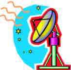
 British physicist Robert Watson-Watt produced the first practical radar ( radio detection and ranging) system in 1935 . It is used to locate objects beyond the range of vision by projecting radio waves against them. Radar can determine the presence and range of an object, its position in space, its size and shape, and its velocity and direction of motion. In addition to its marine uses, it is also used for controlling air traffic, detecting weather patterns and tracking spacecraft.
 The hyperbolic navigation system known as Loran ( Long Range Navigation) was developed in the U.S. between 1940 and 1943 . It uses pulsed radio transmissions from master and slave stations that are received onboard and recorded as small waves on the screen of a cathode-ray tube. The distance between the waves corresponds to the difference in time between the arrival of the signals from the two stations. This difference is represented by a curve (hyperbola). Another set of loran transmitters repeats this process and position is determined by the intersection of the two curves called loran lines of position. Accuracy ranges between a few hundred meters and a few kilometers. Used mainly by US ships it is an expensive system with a limited coverage area and will ultimately be phased out in favor of a newer, more accurate navigation system called GPS.
The Rise of Global Positioning System
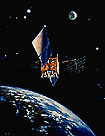
GPS (Global Positioning System), initiated in 1973, is operated and maintained by the U.S. Department of Defense . The earliest GPS system was launched into space back in 1978. Back then only 11 satellites were in use. Now, this space-based radio-navigation system consists of 24 satellites and provides accurate positioning to within about 30 feet as well as velocity and time worldwide in any weather conditions. GPS works the same way as Loran (time difference between separate signals) but the signals come from satellites. Because you can receive GPS signals using small, inexpensive equipment it is being used in many new applications. As far as these systems go, it’s a highly accurate navigation tool. Some GPS systems can produce accurate results down to a matter of feet.
GPS is just one of several satellite navigation systems that exist around the world. Many people assume GPS refers to any satellite navigation but it only refers to the one operated by the United States. Other nations also employ satellite networks. China operates the BeiDou Navigation Satellite System. The European Union uses a system called Galileo. Russia has GLONASS. There are also others that are not world-wide but country or region specific.
Categories: Boats


1 Comment
i don't know the name on September 10, 2020
the flrst western civilization known to have developed the art of navigation at sea were the phoenns, about 4,000 years ago c. 2000 b.c.e. phoenician sailors accomplished navigation by