What You Need to Know About Chart Symbols
Published by Ian Fortey in nauticalknowhow Last updated on March 15, 2022
Learning to drive requires you to learn how to read a map sometimes. Learning how to sail means you need to know how to read charts. Of course, we have a lot of electronics that can do this job for us these days. If you’re ever stuck without power and you need to read a chart, you’ll need to be familiar with chart symbols.
The symbols on nautical charts have been developed by the International Hydrographic Organization. Most of the chart symbols you look up online will be provided by a document called U.S. Chart No. 1, Nautical Chart Symbols, Abbreviations and Terms. This has been developed by the National Geospatial Intelligence Agency (NGA). Also, the National Oceanic and Atmospheric Administration (NOAA). You can get them as paper charts or on electronic chart display. Regardless if you use paper charts or electronic, this info is used all over the world.
U.S. Chart No. 1 covers all waters in America, including the Great Lakes. Knowing all the symbols abbreviations and terms will ensure you can read a chart and sail safely. Though there are other guides out there, U.S. Chart No. 1 is the basis for all the information you’ll find.
Understanding Chart Symbols
There are numerous categories of chart symbols. Not every symbol will appear on every chart and it’s likely some symbols you’ll be totally unfamiliar with. Other chart symbols are very commonplace and it’s good to be able to recognize them. U.S. Chart No. 1 covers even the most obscure symbols.
Most simple chart symbol guides break down the following categories:
Topography: things like landmarks and coastal features
Hydrography: things like currents and depths
Navigation aids: things like buoys and lights. These are the chart symbols most relevant to many boaters.
Index and abbreviations: symbols abbreviations and the index to help navigate them
How to Read Nautical Chart Symbols
On any given nautical chart there is a lot of information. When you understand chart symbols and abbreviations, you can avoid a lot of dangers.
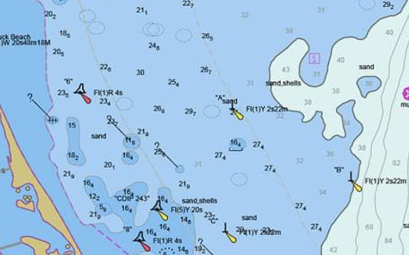
As you can see in the above image, there are many numbers and symbols used on nautical charts. Using U.S. Chart No. 1, you can scroll through the categories to see what everything means. For instance;
Number Chart Symbols: These numbers indicate water depth. You can appreciate why this would be important for sailing.
Tear Drop Chart Symbols: These can be pointed in different directions. When you see a teardrop shape used on nautical charts, that indicates a light and the direction it is pointed.
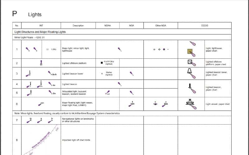
Chart Differences
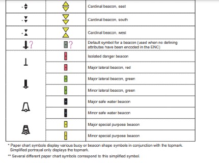
Paper charts and electronic charts can use different symbols to show buoys. For some charts these will be diamond shaped. For others they are separated, like two triangles together in an almost-diamond shape. Navigation aids like buoys are lights are important for sailing, so you definitely want to understand these.
Nautical Chart Symbol Differences

This image shows the difference between buoys on paper and electronic charts.
The left side shows symbols from International Charts and Chart Specifications of the IHO
The center symbols are on charts from the National Oceanic and Atmospheric Administration. That’s usually abbreviated as NOAA.
The right column shows symbols from Electronic Navigational Chart. Also from Electronic Chart Display and Information Systems. Use of ECDIS is required for large commercial ships.
There can be some crossover. For instance, NOAA will often share symbols with International Hydrographic Organization and therefore a column may be blank. However, if the NOAA use their own symbol, it will be present.
All of this is present on Chart No 1.
The Bottom Line
Nautical chart symbols can seem overwhelming at first. When you first see a nautical chart, it’s almost like information overload. Remember that nautical chart symbols are there to keep you safe and more. They provide valuable information and when it comes to being informed, more information is always better. Not every piece of information on every nautical chart will be relevant to you, though.
Chart No 1 is free to download from many websites, including on the National Geospatial Intelligence Agency page. Get your own here to familiarize yourself with the symbols abbreviations and terms. It’s good to check back now and then in case a new edition is released. They will update an edition as new information becomes relevant.
Categories: nauticalknowhow