Understanding Aids To Navigation
Published by Chris Riley in nauticalknowhow Last updated on September 15, 2023
Navigational aids can be found throughout coastal waters, inlets, harbors and more to help you boat safely and efficiently. Understanding what these aids to navigation mean is therefore vital to making the most of your time on the water. You’ll be expecting other boats to follow these navigational aids and they’ll be expecting the same from you.
What Do Aids to Navigation Do?
In order to find our way safely from place to place on the water we must depend on road signs just as we do on land. The aids to navigation are the road signs of the water. Learning to understand them requires experience and practice. However, the benefit to be derived in being able to navigate safely by using the system is well worth the effort.
There are two systems of marking the waterways in the United States; the U.S Aids to Navigation System (ATONS) which includes the Western River System, and the Uniform State Waterway Marking System. Both systems are described below. The Uniform State Waterway Marking System is being phased out in favor of the U.S. ATONS. This change will be gradual and should be complete by 2003. In the meantime, you may see either system in use on state waterways.
Types of Aids to Navigation
U.S. Aids to Navigation (U.S. ATONS)
The buoys and beacons in this system conform to the International Association of Lighthouse Authorities (IALA) guidelines and are located in IALA region B. They are sometimes referred to as the IALA-B system. In this system, there are lateral and non-lateral markers. The lateral markers indicate the navigable channel by their position, shape, coloring, numbering and light characteristics. The non-lateral markers are informational and regulatory markers.
To navigate safely using the lateral markers, you should pass between the red and green. Returning from sea, the red markers are on your right (red, right, returning) and the green are on your left.
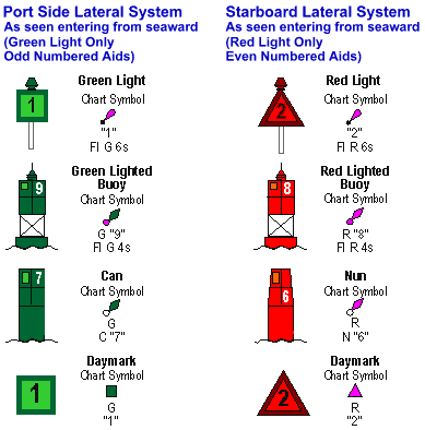
Lateral Buoys and Waterway Markers
In the International system, navigation aids mark the edges of channels to tell which way open water is. They are called day beacons if unlighted, lights if lighted at night, or buoys if they are floating. Some buoys are also lighted for identification at night.
- “Red, Right, Returning” tells you to leave the red markers to your right, or starboard, when returning from sea. The green markers are then left on your port side and between is the channel. Be sure to look behind you when navigating a narrow channel to make sure you are not being pushed out by wind or current.
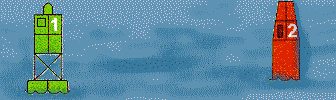
- Floating Red markers are called nuns and are triangular in shape. They are numbered with even numbers. Floating Green markers, on the other hand, are called cans and are square or shaped like a large can and carry odd numbers.
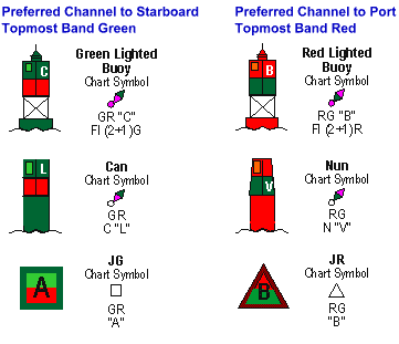
Preferred Channel Markers or Junction Markers
These indicate the preferred channel at points where the waterway splits or branches off in another direction. If you are returning from sea and see a preferred channel marker that is red over green, to stay in the main channel you would consider the marker as if it were a red marker and keep it on your right. However, if your intended destination is the waterway branch consider the marker a green marker and leave to your port side. (See example below.)
When looking at a chart you read the markers as follows:
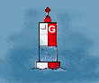
| The first marker you see entering from sea is the open, or safe water, marker. The RW “G” means that it is a Red and White striped marker with, in this case, the letter “G” on it. | |
 |
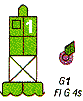
A lighted marker flashes at night and during restricted visibility. The next marker you see as you enter this waterway is the G “1” Fl G 4 sec. This tells you it is Green, has the number 1 on it, and it Flashes Green once each 4 seconds. |
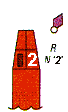  |
R N “2” plus the red symbol indicates a Red Nun buoy with the even number 2 on it. Conversely G C “3”, is a Green Can buoy with the odd number 3 on it. |
 |
When entering from seaward you may find two channels which separate and go in different directions. A junction marker referred to as RGN “C” uses its top color to show you the major or primary channel. This is represented by a Red and Green Nun buoy with (in this case) a “C” on it. You use the top color and shape as if it were a stand alone marker if you want to follow the primary channel. In this case leave the Red Nun to the right. Otherwise use the bottom color. |
Intracoastal Waterway System
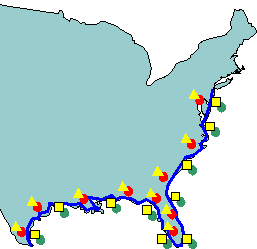
The Intracoastal Waterway (ICW) runs parallel to the Atlantic and Gulf Coasts from Manasquan Inlet on the New Jersey shore to Brownsville, Texas at the Mexican border. Aids to navigation marking these waterways have some portion of them marked with yellow. Otherwise, the colors and numbering of buoys and day marks, and lights follow the same system as that observed in all other waterways.
Red, right, returning also applies to the ICW markers. However, how do you know which way is returning?
- Generally south, from New Jersey to Brownsville, Texas is considered returning. So, going generally south on the ICW you would have red right. There are some areas of the ICW such as the West Coast of Florida where you are actually going north. Still, if you are going from New Jersey to Texas you are returning.
- Aids to navigation marking the Intracoastal Waterway (ICW) display unique yellow symbols to distinguish them from aids marking other waters. Yellow triangles indicate aids should be passed by keeping them on the starboard side of the vessel. Yellow squares indicate aids should be passed by keeping them on the port side of the vessel. A yellow horizontal band has no lateral significance, but simply identifies aids as marking the ICW.

Dual Purpose Markings
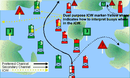
- Red Buoy with yellow square — marks left side of channel when traveling the intracoastal waterway (south), but right side of channel when coming in from sea.
- Green Buoy with yellow triangle — marks right side of channel when traveling the intracoastal waterway (south), but left side of channel when coming in from sea.
- Red Buoy with yellow triangle — marks right side of channel when traveling the intracoastal waterway (south), and right side of channel when coming in from sea.
- Green Buoy with yellow square — marks left side of the channel when traveling the intracoastal waterway (south), and left side of channel when coming in from sea.
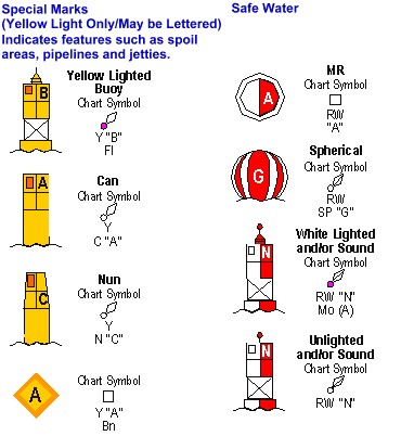
Non-Lateral Informational and Regulatory Markers
Regulatory or informational markers are used to advise you of situations, dangers, or directions. They may indicate shoals, swim areas, speed zones, etc. They can be easily identified by the orange bands on the top and bottom of each buoy.
|
|
|
 Controlled Area: Type of control is indicated in the circle, such as slow, no wake, anchoring, etc. |
|
|
 Buoy used to display regulatory markers. |
 May show white light May be lettered |


Other Non-Lateral Markers
| Safe Water Marker: These are white with red vertical stripes and indicate unobstructed water on all sides. They mark mid-channels or fairways and may be passed on either side. |

|
| Inland Waters Obstruction Marker: These are white with black vertical stripes and indicate an obstruction to navigation. You should not pass between these buoys and the shore. |

|
| Mooring Buoys: These are white with a blue horizontal band. They are usually placed in marinas and other areas where vessels are allowed to anchor. These are the only buoys you may legally tie up to. |

|
Western Waterway Marking System
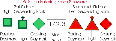
Found only on the Mississippi River and its tributaries as defined by the U.S. Coast Guard in Rule 3 of the COLREGs. These aids to navigation are not numbered as in IALA-B system. Numbers indicate mileage from a fixed point. Lights on green aids show a single-flash which may be green or white. Lights on red aids show a group-flash which may be red or white. Diamond-shaped crossing dayboards, red or green as appropriate, are used to indicate where the river channel crosses one bank to the other.
Uniform State Waterway Marking System (USWMS)
On bodies of water wholly within state boundaries and not navigable to the sea, each state is responsible for establishing and maintaining aids to navigation. A uniform system of aids and regulatory markers has been agreed to by all states
Some informational/warning flags you might see include:
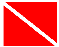
Divers’ Flag indicates that scuba divers or snorkelers are operating in the area. Stay well clear of this flag. Many states have specific distance-away requirements from 100 to 300 feet. Check your state regulations.
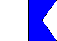
Rigid Alpha Flag is flown by a vessel engaged in diving operations. This flag does not substitute for the diver-down flag above in states that require the diver-down flag. You will usually see both flags in use. The alpha flag indicates that the vessel is restricted in ability to maneuver, in this case due to the nature of its work.
Additional Markers To Know
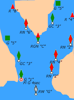
| What are all those red and green things? | |
1.  – – | 1. Preferred Channel Marker , Red and Green Nun labeled with the letter “C” in this example . Because top color is red you would treat the marker as a red nun if you want to take the preferred channel. |
| 2. | 2. Lighted MOA (morse code alpha) fairway or safe water marker labeled with the letter G in this example. This marks center of channel and can be passed on either side. Light will flash morse code alpha one short and one long (di dah) |
3.  | 3. USWMS regulatory buoy . In a danger area the danger would be printed in the diamond. |
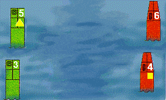
4.  – – | 4. Lighted green ” Can Buoy “, port side channel marker returning from the sea. Flashing Green light every 4 seconds. Labeled with the number 1 in this example. |
5.  – – | 5. Unlighted ” Nun Buoy ” starboard channel marker when returning from the sea. Labeled with the number 2 in this example. |
6.  | 6. Unlighted Can Buoy marks the left side of the channel returning from sea. Labeled with the number 3 in this example. |
Using Aids to Navigation
| So how do you use these markers practically? Let’s run through an example. You are fishing offshore when you hear storm warnings on your radio. You decide to head for the nearest inlet. You encounter the following buoys in the following order. What do they mean and what should you do? |
 This maker indicates a mid-channel or safe water mark. This will usually be the first marker you see returning from sea. It will not have a number and may be lettered. It may be lighted or unlighted and may have an associated sound. The light (if lighted) will be white and will flash the Mo (A) sequence. (Morse Code Alpha). You may pass to either side of the marker. |
 This represents the next set of markers you might see when returning from sea. You should pass between them leaving the red marker on your starboard side. Remember “RED RIGHT RETURNING” . The red “Nun” starboard side markers are even-numbered and, if lighted, have red lights. The green “Can” port side markers are odd numbered and, if lighted, have green lights. |
 This is a preferred channel or junction marker and indicates a bi-furcation in the channel. To navigate the preferred or primary channel, you should treat the marker as if it had all the characteristics of the color of the top band. If the top band is red, such as the one shown above, you would treat it as a red, starboard side marker (leave it on your right) to access the primary channel. If the top band is green, you would treat it as a port side marker to access the primary channel. If lighted, the marker would have a light the same color as the top band. |
 This is where it gets a little tricky. The yellow triangle and yellow square are dual purpose marks where the Intracoastal Waterway (ICW) and other waterways coincide. Now what? |
Question 1: Between which markers and in which direction (right or left) would you turn to follow the ICW going north? To enter the ICW in a northerly direction you would turn starboard (right) between red marker #4 with the yellow square and red marker #6. |
| Question 2: Between which markers and in which direction (right or left) would you turn to follow the ICW going South? To enter the ICW in a southerly direction you would turn port (left) between green marker # 3 and green marker #5 with the yellow triangle. |
| Question 3: How do you know which direction to turn to go north or south? The ICW is a special waterway which runs from New Jersey to Texas. Traveling from New Jersey to Texas is considered returning so you would have Red Right Returning when going “generally” south, or from NJ to TX regardless of compass setting. Now, remember those dual purpose yellow markers? (The yellow triangle represents a red nun buoy and the yellow square represents a green can buoy.) These are found, on the ICW, in areas where other waterways connect with or cross the ICW. When operating in the ICW, take note of the yellow triangles and yellow squares and treat them as the buoys they represent no matter what the color of the buoy they are on. . 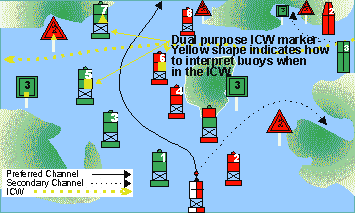 |
 Another way to remember this is to think of the ICW (the blue line) as a ditch just inland of the waters surrounding the US from New Jersey to Texas. You would always keep the yellow triangles or red markers on the land side and the yellow squares or green markers on the “green” ocean/Gulf side. |
Categories: nauticalknowhow


3 Comments
Rudy Shappee on May 7, 2020
What does a lighted nun buoy look like?
W f Jones on September 6, 2020
What does a square green sign with the letters in NS mean?
Dalton Bourne on August 22, 2022
If you encounter a red buoy and a green buoy on your way back to the home port from seaward, your boat is entering a channel. Both red buoys and green buoys are known as lateral markers and assist you in determining which side you should pass on to stay in a channel: Based on general guidelines, regardless of whether you are moving from waterways to inland water or a river’s upstream in a river, keep the red buoys to your right and the green markers to your left.